Yak Peak
- Kaitlin
- Aug 20, 2019
- 1 min read
August 20, 2019
Distance: 6.5km
Elevation gain: 768m
Time required: 3-4 hours
Yak Peak is a distinctive granite slab that can be very clearly seen on the north side of the Coquihalla Highway. It's a favourite of mine to look at when driving. Now I actually got the chance to hike it. There are separate hiker's and climber's routes.
The parking lot is at the Zophois Brake Check & Rest Area on the north side of the Coquihalla Highway past Hope. From there, you must walk about 300m along the side of the highway until seeing some flagging tape heading off into the trees.
The hike is short but steep. It starts off with a steep forested ascent. This is the easy part. It then leads out to the base of Yak's massive granite slabs where you hike around the right side of the slabs. This is where most of the elevation is gained. This opens up into a meadow leading to the false summit of Yak. It's then a scramble to the true summit which involves a few technical moves but nothing too difficult. It will take most people 1.5-2 hours to complete this.


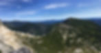
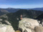


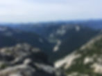
The views can't be beat. Keep in mind that most of the hike is exposed and there is no water anywhere on the trail. However, it is not overly long so water should not be an issue.